Bikeable Auckland

Reckons, Vote Avery

I’m on the Bike-Friendly Candidates page on the BikeableAuckland.nz site:

“I’ve been doored off by a courier and gone sprawling in traffic on Ponsonby Rd, gone tumbling head over heels over a drunk driver, and barely grabbed onto the roof rack to stay out from underneath a car that turned through me on K Rd. Oddly enough, now the thought of my son ever riding on Auckland roads gives me the absolute shivers, but with improved cycling infrastructure – namely more protected cycle lanes, plus the protection we’ll get once we hit a critical mass of riders and even antagonistic drivers have to start taking us seriously – my shivers will go away and my boy, in a few years when he learns to ride, will be allowed to do the apparently reckless things that we all took for granted when we were kids – like bike to the shops to get a bag of jet planes or into town to see a movie. Vote Avery, no more shivers.”

If you’re interested in a more bikeable city out the statements of all the listed candidate’s for your ward, in my experience just as cars are associated with bad cities, bicycle-friendliness is a sign of a good city, if you agree make sure you give your ticks to bike-friendly candidates.

Light rail, Auckland’s future

Reckons, Vote Avery

A quick note: My thinking on light rail is heavily informed by Auckland Transport‘s published investigations and reports, and also by following Transport Blog‘s many discussions of the subject over years. I’m also a believer in some of the promises of the Congestion Free Network, but their ideas lean more on buses and less on light rail than I’d prefer.

The image above is one of Auckland Transport’s proposed future transport network maps for 2045, the four spurs down through the central isthmus (to Owairaka, Mount Roskill, Three Kings, and Onehunga) and one line across the harbour to Akoranga are light rail lines.

Here’s the Congestion Free Network proposal for 2030:
Auckland Congestion Free Network Proposal

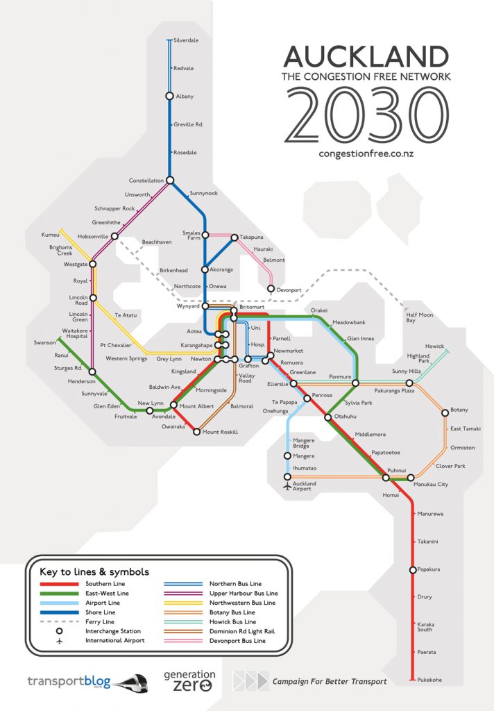
You can see they also plan for a new Light rail line, though this is on a different time scale from Auckland transports proposal above, so they only have a single light rail line, this one going from Queen St, down Dominion Rd through Balmoral and terminating at Mount Roskill, where it would join up with the Southern Line rail line.

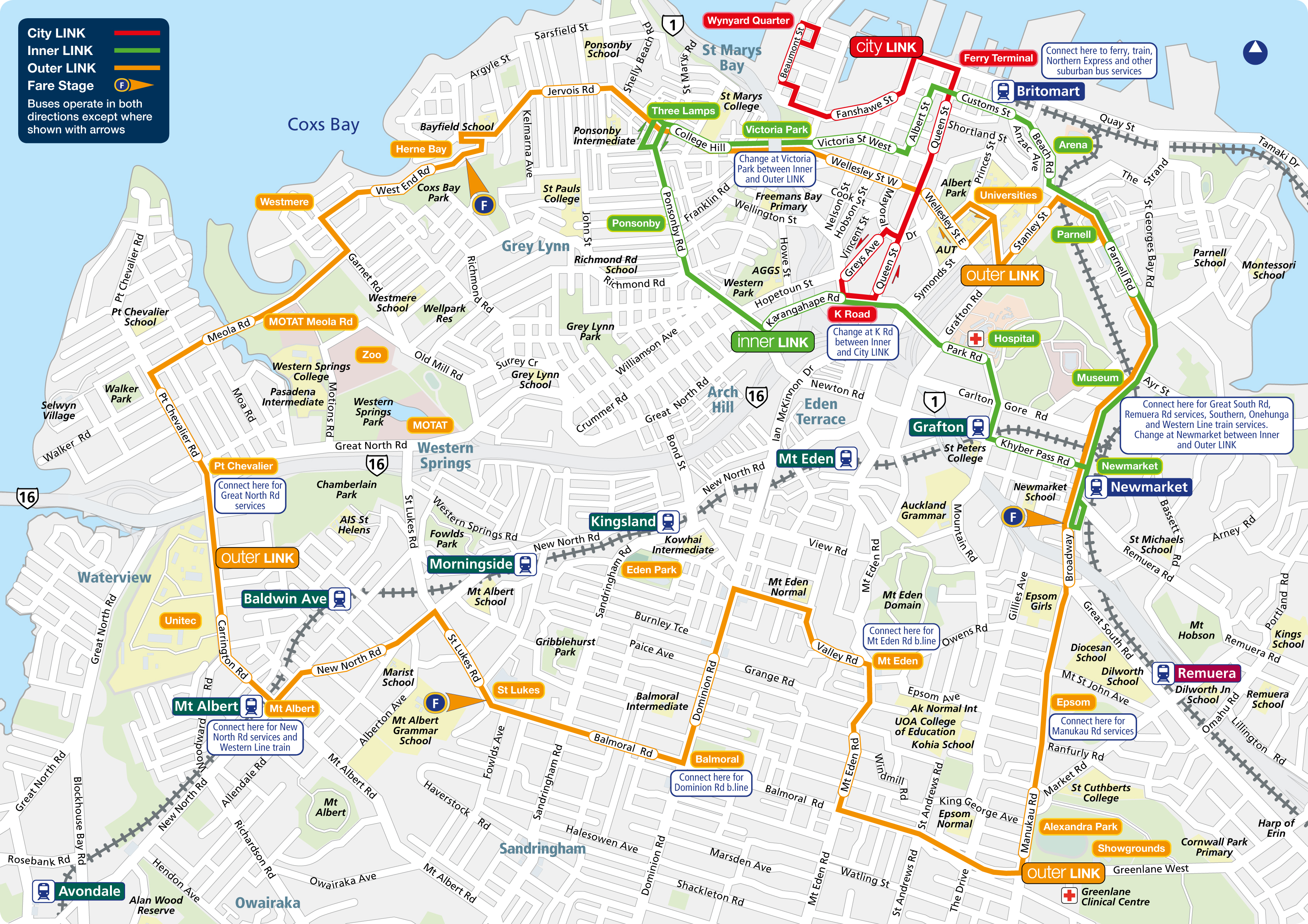
These are both fine ideas, and very important long term plans, but my addition is that we also put in a tram line essentially replacing the current Inner Link route.

Link Bus Route Map

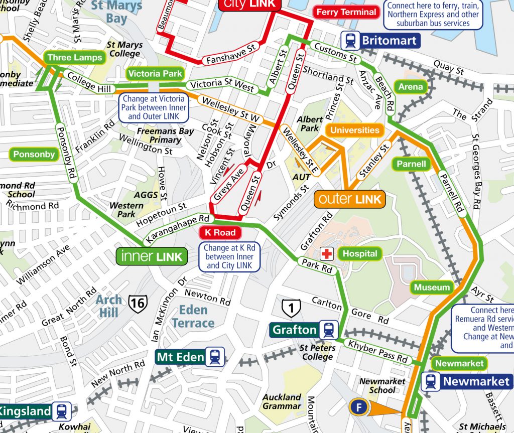
This would provide us with a light rail link fed from Britomart at the bottom of town, through Three Lamps, along Ponsonby Rd, and along K Rd, where we could allow transfers to the rail network via the new City Rail Link station, then continue past the hospital, through Newmarket, past the museum and down through Parnell back to Britomart. The only major stops it doesn’t go directly past Auckland University or AUT, so perhaps some slight deviation could be made.

Now yes we do of course already have a bus running this route, but these roads will become ever more congested over coming decades and trams/light rail have higher throughput than buses, they’re simply more efficient, so I feel like this would be a really fantastic journey that would be taken by thousands every day, what do you think?


A few more notes: There is a large and important distinction to be made between trams and light rail, trams are at street level and share space with other road users, light rail can look quite similar but has its own space – either a  dedicated right of way, or preferably physical/grade separation from other traffic.

This means light rail can move much faster than surrounding traffic and isn’t bound by congestion in other transport modes. Separate light rail has three times the maximum capacity of a dedicated Busway, at 18,000 passengers per hour – which is to say that you’d have to put in three northern express busways to match the throughput of a light rail pair, even though light rail could be installed in the same space taken up by the busway.

It’s really efficient. This means you can get more people where they want to go, on time, and in comfort. And by design it can be very safe for other road users (naturally great care needs to be taken in how you design any intersections where other traffic crosses over the lines).

If you’ve only ridden the Wynyard Quarter or Motat trams then please know light rail is nothing like those. They’re historical artifacts and would be a cramped, pokey, and slow way to get around. I can’t even fit my knees in the seats and I’m only 6 foot tall. No one advocating for light rail is advocating for that kind of tram to be used for anything other than a curiosity for tourists.

I’ve used modern light rail in Japan, Belgium, and Australia. It is fantastic, it’s very fast and very comfortable. In some respects it isn’t all that different from from taking a modern train, except that it costs a lot less to install the infrastructure.

Trams, Auckland’s past

Reckons, Vote Avery

There are no two ways about it, Auckland was a public transport city.

People have always driven of course, but the way many people got around was on the electrified tram network that our forebears built and enjoyed from 1884 (beginning with horse drawn trams, and with electric trams introduced in 1902) right up until 1956.

Now you have to be pretty old to really remember the tram network, and I’m about 20 or 30 years too young to have seen it in operation, though I do remember some bits of line were still visible when I was a child in the 1970s and 1980s.

But many of us know that there used to be a lot of trams around, perhaps without being able to fully visiualise just how many, then a year or so ago designer Cornelius Blank decided to make a modern metro-style transit map of the network. I think it really drives things home using a design language that many of us find easier to relate to than the more old-fashioned network maps that were previously available.

It breaks my heart to look at that network and imagine how different Auckland would be today.

The lines were everywhere. You could take a tram to Parnell, or Meadowbank, or Ponsonby, or even much further afield to Avondale, Mt Albert, or Onehunga, and there are stories that the trams were so popular and convenient that you’d often be able to see the next tram coming when you were getting on the one already at your stop.

But then in the 1940s and 1950s in a move of vandalism on an epic scale the lines were all closed, then the rails were gradually ripped up or paved over.

Now, to be totally clear about this some of the tram lines were economic failures – there weren’t enough people for them to operate. The Devonport line in particular lived and died over just a couple of years – but it was a horse drawn line in 1880s Devonport, 70 years before the harbour bridge opened up the shore. But other lines, popular, successful lines, were also shuttered and destroyed, with the now nameless bureaucrats claiming that we’d have a more modern transport network if we adopted diesel buses rather than continuing with the clean electric trams.

We now know with the certainty of hindsight what I’m sure many knew back then: this was a preposterous notion and a failure on an historic level.

But it’s a failure that we can start to correct if we wish it. It will take time, but we can do it.

I wish it.


Metro-style Auckland Historical Tram network map created by Cornelius Blank, used with permission.